On 27 January 2014, Kerry International Dark Sky Reserve — covering approximately 700 km² of the Iveragh Peninsula in southwest Ireland — became the first Gold Tier IDA Dark Sky Reserve in the northern hemisphere. Its SQM core readings reach approximately 21.8 mag/arcsec², supported by an Atlantik-facing horizon that admits no urban skyglow to the west. Below the stars: Bronze Age stone circles, a UNESCO World Heritage monastery carved into a sea stack twelve kilometres offshore, and nearly 4,000 permanent residents who chose, through their local councils, to retrofit their street lighting rather than lose the sky above them. For the full European network context, see our guide to dark sky places in Europe.
The Iveragh Peninsula — Shape and Geography of the Reserve
Kerry’s reserve sits on a peninsula where the Atlantic sets the western horizon at zero — no coastline, no shipping lanes, no town between Ballinskelligs Bay and North America.
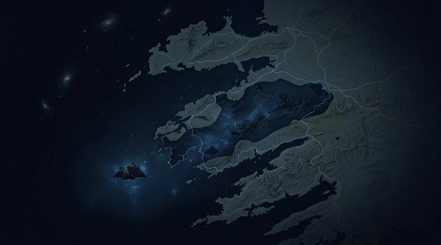
The Iveragh Peninsula juts southwestward into the Atlantic from County Kerry in Ireland’s southwest corner. The reserve encompasses nine community areas across approximately 700 km²: Kells, Cahersiveen, Portmagee, Valentia Island, The Glen–St. Finian’s Bay, Ballinskelligs, Waterville, Dromid, and Caherdaniel. The Ring of Kerry — the N70 scenic route that circuits the peninsula — passes through most of these communities. Offshore, the Skellig Islands mark the westernmost edge of the reserve’s visual geography, rising from the ocean roughly 12 km from the Portmagee coast.
The topography is karst-influenced and heavily indented: a series of bays, headlands, and mountain ridges that include MacGillycuddy’s Reeks — Ireland’s highest mountain range — to the north and east. That ridge provides a natural barrier against light pollution from Killarney and Tralee. To the south, the sea. To the west, nothing between the peninsula’s headlands and the American coast. The resulting sky geometry is unusual: three sides partly shielded by terrain or low ambient-light zones, and a clear western arc reaching to the horizon without interference. This is the structural basis for the reserve’s Gold Tier sky quality — not just low population density but an ocean-facing aperture of genuine darkness.
The reserve was designated not by designating an uninhabited wilderness. Nearly 4,000 people live within its boundaries. That number includes farmers, fishermen, tourism operators, and community councils, all of whom had to commit to the lighting management changes the IDA Gold designation requires. That is what makes the Kerry case instructive — and different from any wilderness reserve.
Why Gold Tier Matters
IDA’s Gold Tier is not a tourism grade. It is the most demanding standard in the Reserve category, requiring core SQM readings above 21.8 mag/arcsec² and demonstrated long-term community governance — not a one-time threshold pass.
The IDA Reserve designation uses three tiers — Bronze, Silver, Gold — to differentiate sky quality within a framework that also requires active governance of buffer zones. Bronze requires Bortle Class 3 conditions in the dark core. Silver moves to Bortle Class 2 with documented active management. Gold demands a core SQM of at least 21.8 mag/arcsec², together with active lighting management extending into the surrounding communities and five-year recertification cycles demonstrating maintained or improved sky quality.
Kerry received Gold Tier status at designation in January 2014 — the first reserve in the northern hemisphere to do so. The significance of the inhabited qualifier is genuine. IDA Dark Sky Sanctuaries — the category reserved for extremely remote, minimally populated sites — are straightforward to manage because outdoor lighting is essentially absent by default. A reserve where people live, drive roads, run farm operations, and operate guesthouses is a governance challenge of a different order. Kerry’s Gold designation proved that the Gold standard was achievable in a living community, not only in uninhabited wilderness. For the taxonomy of IDA certification types and how reserves differ from parks and sanctuaries, see the European dark sky places pillar H2-2 section.
Recertification is not automatic. Kerry has maintained its Gold status through active local engagement — a fact the IDA submission documents record in terms of ongoing SQM monitoring, lighting ordinance compliance, and community education. The designation does not fossilise a moment. It requires a sustained choice to keep the sky dark.
The Sky Itself — SQM and What to Expect
Core zone readings of approximately 21.8 mag/arcsec² place Kerry among the darkest certified reserve sites in Europe — comparable to Northumberland’s documented peak, and achieved at a latitude where Atlantic weather, not urban glow, is the primary observing constraint.
The benchmark reading of 21.8 mag/arcsec² corresponds to Bortle Class 2 conditions: the Milky Way is clearly visible with distinct dust lanes, zodiacal light casts faint shadows on moonless nights, and M33 (the Triangulum Galaxy) can be detected by direct vision. These are exceptional conditions for a site with permanent residents. The comparison point is instructive: most European cities sit at 17–18 mag/arcsec² (Bortle Class 7–8). Kerry’s core is roughly 60 times darker in terms of measured sky luminance.
Best viewpoints within the reserve include Derrynane Beach (directly within the darkest core), the elevated Coomanaspig Pass on the Skellig Ring near Portmagee, and the old watchtower at Bray Head on Valentia Island, which looks out to both the Skellig Islands and the Blasket Islands. The Skellig Experience Visitor Centre on Valentia Island operates as an orientation and exhibition point. Bolus Head, a promontory above Ballinskelligs Bay, provides a near-360-degree horizon.
Aurora borealis is occasionally visible from Kerry. The reserve sits at 52°N — south of the main auroral oval — but strong geomagnetic events (Kp index ≥6) have produced visible aurora along the southern Irish coastline. These are not guaranteed sightings, and Kerry should not be marketed as an aurora destination. The primary draw is the Milky Way, planetary visibility, and deep-sky objects under conditions that most visitors from western European cities will find disorienting in the best sense. For the SQM instrument methodology behind these readings, see measuring light pollution: methods, data, and research tools. For how sky brightness data connects to the broader research record, see our overview at SQM buyer’s guide.
Heritage — Skellig Michael and the Stone Circles
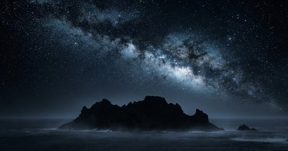
The sky above Kerry was used as an instrument long before the IDA existed. The stone circles and a monastery built into a sea cliff twelve kilometres offshore were both sited with specific attention to the celestial horizon.
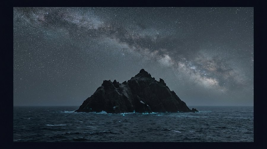
Skellig Michael — Sceilg Mhichíl — is a UNESCO World Heritage Site (inscribed 1996) located 12 km off the Portmagee coast, a pyramidal sea stack rising 218 metres from the Atlantic. Monks of the Celtic Christian tradition founded a monastery there between the 6th and 8th centuries. The complex — six beehive domed cells, two oratories, a medieval church, and a cemetery, built at 180 metres above sea level on hand-cut terraces — was occupied continuously until the late 12th or early 13th century. The site was chosen partly for isolation, partly for access to the sea, and partly for its position on the horizon: the island’s eastern face catches the first light of the equinox sunrise. Pilgrimage continued through the modern era. The monastery was not built in darkness but was used, night after night, by monks whose only light was fire, whose only time-keeper was the sky.
On the mainland, Bronze Age stone circles concentrate in the Kenmare River valley and the Iveragh Peninsula. The Kenmare Stone Circle — an egg-shaped monument measuring approximately 17.4 x 15.8 metres — is among the largest in southwest Ireland. Stone circles in this region are characteristically aligned on a northeast-to-southwest axis: where a clear horizon exists, this orientation faces the setting sun at the midsummer solstice. The alignment is not decorative. It encodes a calendrical function — a fixed marker in a landscape whose people needed to track the solar year. Eightercua, a four-stone alignment near Waterville, adds to the archaeoastronomical record of the peninsula.
Kerry’s heritage is not tourist marketing. These sites were built under skies the Gold Tier designation is now trying, imperfectly, to recover. A stone circle aligned to the midsummer solstice makes no sense under sodium streetlights. It was built in darkness and reads correctly only in darkness. For the cultural loss dimension that this heritage counterbalances, see our article on noctalgia: the language of losing the night sky.
Community Lighting Management
Kerry County Council was the first local authority in Ireland to commit to a reserve-wide LED street lighting upgrade — a decision driven by the IDA designation process and the lighting management plan it requires.
The Gold Tier designation carried a condition: the surrounding buffer communities had to adopt and implement a lighting management plan compliant with IDA standards. The three-year campaign by the Kerry Dark Sky Group — which drove the application from 2011 to 2014 — involved educating local citizens, civic organisations, and all nine community councils on the IDA requirements. Several towns and villages enacted local ordinances on responsible outdoor lighting before the designation was awarded.
Kerry County Council responded by committing to replace public street lighting throughout the county with dark-sky-compliant LED fixtures. The upgrade targeted the 400 lights in the core reserve area — from Kells to Caherdaniel — first. The LED system adopted full-cutoff shields and warm-spectrum output, reducing upward light emission to IDA-compliant levels. The council cited both dark-sky compliance and energy cost reduction (approximately 30%) as motivations. That dual justification — conservation and cost — was key to council adoption. Dark-sky advocacy that can point to reduced electricity bills reaches councils faster than conservation arguments alone.
Farm yard lighting within the reserve presented a harder challenge. Voluntary retrofit schemes, supported by Dark Sky Ireland and the Kerry Dark Sky Group, encouraged landowners to replace open-face security lights with full-cutoff alternatives. Uptake was partial but documented. The reserve functions not because it achieved perfect compliance but because the governance framework — council ordinances plus voluntary community engagement — created enough reduction in aggregate upward light emission to sustain core SQM readings above the Gold threshold. For the policy contrast with France’s national-level approach, see our article on France’s 2018 lighting decree. For the broader engineering toolkit behind dark-sky-compliant lighting, see how to reduce light pollution.
How to Visit and When
The reserve is accessible by road, free to enter, and best experienced in the new moon window between September and March — though the Skellig Coast Dark Sky Festival each spring offers organised events for those who prefer a structured introduction.
The N70 Ring of Kerry is the primary access road. Ballinskelligs, Waterville, and Caherdaniel form the practical accommodation cluster at the heart of the dark core. The reserve’s nine communities each offer accommodation options, but these are small villages: booking ahead is sensible, particularly during the annual Skellig Coast Dark Sky Festival — a not-for-profit, community-run event held each spring by Comhchoiste Ghaeltacht Uíbh Ráthaigh, featuring astronomer-led stargazing sessions, astrophotography workshops, nature-by-night walks, and astrophysics talks.
Best months for observing: September through March, when nights are long and the Milky Way core is visible from late evening. Dark adaptation — the 20-to-30-minute process by which rod photoreceptors reach full sensitivity — is disrupted by any white light source. Red-light torches are standard. The western horizon at Derrynane Beach is the reserve’s best open-sky vantage for wide-field Milky Way photography. Check Kerry Dark Sky Tourism (kerrydarkskytourism.com) for current event schedules and guided stargazing dates. For the sibling flagship profiles in the dark sky places series, see Galloway Forest Park — Europe’s first dark sky park and Øvre Pasvik — Europe’s northernmost dark sky park.
Frequently Asked Questions
What makes Kerry a Gold Tier Dark Sky Reserve?
Gold Tier is the highest standard in the IDA Dark Sky Reserve category. It requires a core zone SQM of at least 21.8 mag/arcsec² — equivalent to Bortle Class 2 conditions where the Milky Way is clearly visible with dust lanes — plus active lighting management in the surrounding buffer communities and five-year recertification cycles. Kerry was designated Gold Tier in January 2014, the first reserve in the northern hemisphere to reach that standard. The designation is not permanent: Kerry has maintained Gold status through ongoing community council compliance and SQM monitoring across the reserve’s nine community areas.
Can I visit Skellig Michael during a dark-sky visit?
Skellig Michael is accessible by licensed boat from Portmagee, Ballinskelligs, or Caherdaniel between approximately May and October — the landing season depends on sea conditions and OPW permit availability. Landings are during daylight hours; the island does not permit overnight stays. A dark-sky visit to Kerry therefore separates naturally into daytime archaeology (Skellig Michael, stone circles) and evening astronomy. The Skellig Experience Visitor Centre on Valentia Island runs exhibitions year-round and is a reasonable orientation point regardless of whether a sea crossing is possible. Book Skellig Michael boat trips well in advance — licensed places are limited and fill weeks ahead during summer.
What equipment do I need for Kerry stargazing?
Naked-eye observation of the Milky Way, bright nebulae, and star clusters requires no equipment beyond dark adaptation — 20 to 30 minutes away from white light sources. Binoculars (10×50 or similar) open up the Milky Way’s structure, the Pleiades, and the Andromeda Galaxy. A telescope is not necessary for a first visit. Red-light torch is essential for navigation without destroying dark adaptation. Warm, waterproof clothing matters more than optical kit: Kerry’s Atlantic exposure means wind and damp even on clear nights. A sky chart app (Stellarium, SkySafari) set to red-night mode and downloaded for offline use covers most practical needs.